The Trip Report: Day one; Friday Aug 4th; Getting From Calgary to Virginia Falls Campsite.
The Expectations for this canoe trip are high. In Canadian paddling circles the Nahanni river is to Canoeing as the West Coast Trail is to Hiking.
We are going on a non-guided trip. This has scared off a couple of the people from joining us. Initially we got together with a group of 6 or so others that were interested. Of the 6 two were very interested, but lacked canoe tripping experience. Still undaunted they were willing to commit to a summer of canoe learning to make the trip. Regrettably a personal event caused one of the pair to drop out, taking her partner with her. So up until a month before the trip date it looked like it would be just my buddy Richard and myself. Then a friend of Richard took a crash canoe course summer and joined the group.
Three of us off to the Nahanni, one tandem and one solo canoe. The plan is simple enough, bring every thing we need, except the canoes, a barrel, and a canoe repair kit which we would rent in ft. Simpson.
Rich and I fly out of Edmonton 7:00AM on Friday, a brief lay over in Yellowknife and off to Ft. Simpson. 3 hours later we are in the air again, this time in a Cessna with our canoe and gear being flown over the RAM plateaux and dropped off at Virginia falls around 5:00PM. Glen comes up later on a flight from Calgary.
Some notes on flying/set up, and on Ft. Simpson in general.
1) We booked with Air Canada, giving us 2 bags, and a total weight allowance of 100lbs. Glen booked elsewhere, and with the same airline had half the same allowance. He ended up paying an additional $50.
2) We took our paddles... on the way up they were free, but had to be loaded as extra baggage on the way back.
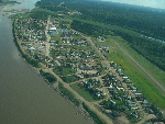
3) Ft. Simpson (pop. 1200 or so), has a grocery store, where you can buy fresh produce, and the like.
4) In Ft. Simpson you need to check-in at the wardens office for the Nahanni river rip. I believe the building closes at 5:00, I'm not sure how you do this after 5:00. We checked in for Glen, assuming he would not have time.
5) There is a public Laundry mat in Ft. Simpson, it is part of the Green and white apartment building, there is a plywood encased door... that's the one. I was going to do laundry after the the trip, but unfortunately the soap machine was empty, and I did not go to the store to buy some laundry soap, and left it for when I got home.
6) There is a 'one bottle limit' at the liquor store... I'm not sure how this is enforced for groups heading out for a week long trip, but our taxi driver was complaining about it.
7) The Airport is about 16km from Ft. Simpson.... but the kind folks at Simpson Air had time to come and picked us up. (The Cessna takes off from the MacKenzie River, which runs through town)
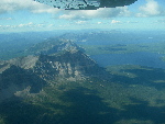
The Cessna flight was an interesting one for me. I've never been in a plane that small before. With the load of one canoe, Three people (including the pilot). It took most of the flight to get up to altitude to make it over the RAM Plateaux, and up to Virginia falls. The land up there is marked with cut lines from survey work done in the 70's, and then once you are over the first ridge there is a point where you see the winter road from a local mine. Other than that, the flight is nearly two hours of flying over land that has little obvious signs of human disturbance.
Little Doctor lake (?)
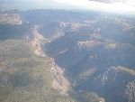
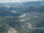
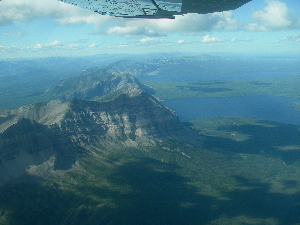
At the first ridge, there is Little Doctor lake, which runs through the ridge. It looks very picturesque. The pilot tells us that Simpson Air runs a cabin on the lake. It could be a nice place to really get away from it all, if you do not want the 'trouble' of paddle out of the wilderness. After the frist ridge is the RAM plateaux. The Ram plateaux, is turning into mountains.

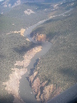
Valleys cut through Ram Plateau
It is something I'd never imagined. As the rivers and streams cut down into the plateaux, cutting deep valleys, the mountains are rising up around them. It is interesting seeing mountains where the tops are completely flat on some.
The Pilot, I think his name was Alex, tells of how Patterson, when he was getting on in age still used to make the trip into town during the dead of winter. That is a three day trip, by dog sled, and that he'd do it when it was -60c, and he was about the same age. They just do not make people that tough any more, at least not where I'm from.
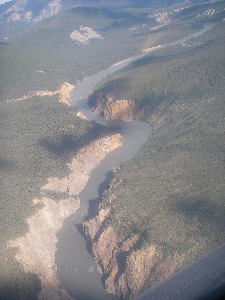
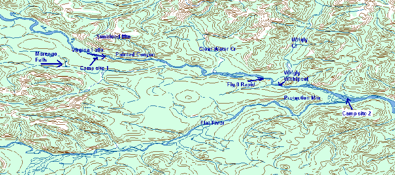
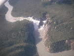
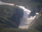
Looking down on Painted Canyon
The last portion of the flight joins the course of the Nahanni River, The pilot flies above, and along the painted Canyon (aka 5 mile canyon, and the forth canyon). We see the waves below that make up the 5 mile canyon rapids, they look like they could be huge, but there is no real perspective. Then as we round the corner Virginia Falls comes into view. Very spectacular. The pilot runs a loop giving both Rich and I a good view of the falls, and again back along the canyon as he drops elevation.
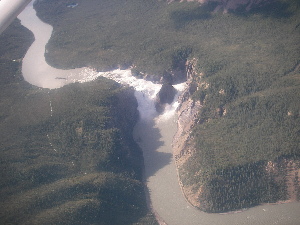
Virgina Falls and Portage trail
After that he flies over the falls. The camp site is in view. A massive board walk structure is in place, with towers for food caches. One final turn, with an exciting-swooping-droping-bank turn down to near river level, followed by the smoothest landing I've ever had in an air plane and we were down.

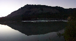
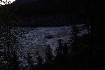
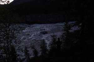
Doc at Virgia Falls campsite. Looking down towards Sluice box rapids.
Then it was a float over to the doc, and the unloading began. The pilot still had to go back and get Glen and his stuff. We set up camp for the night, already I was tired just from being awake so long. We cooked supper, A combination of Steak and Pasta. In between the Steak and pasta we listened to an interpretive discussion on De-cho/Dene (sp?) customs related to going through adolescence.
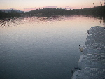
After that, we took the time to walk down to Virginia Falls and look around a bit. It was getting late, past 10:00pm, but still lots of light. The walk down to Virgina falls is an easy walk on a raised boardwalk. The boardwalk has obviously been replaced from years ago, and look nearly new. Only a few sections being effected by some shifting in the ground below, adding a new curve, and some slanting to the boardwalk. It is a very easy � hour (if that) walk to the falls.
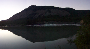
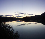
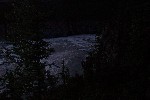
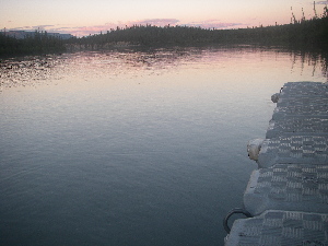
Sunblood Mtn in the evening
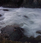
First you come to the the starting point to the take out for the portage. It is right accross from "last chance Island", a small island just above the sluce box rapid, that leads to the falls them selves. The water is very slow and like glass tonight. It crossess a line, speeds up and becomes a massive rapid. We, probably like most, scan the rapid, and wonder just how far you could make it down. I'm thinking 'not far'. The Sluce box then splits in the middle around Mason's Rock, and plunges over the falls. Very very impresive the amount of raw power. The speed of the water as it shoots over the edge is incredible, I wonder how fast it is actually moving.
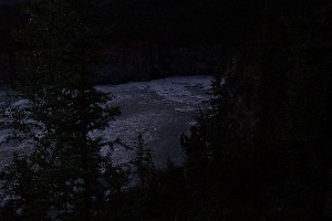
There is a couple down on some rocks running out into the sluice box rapid, just priror to the fall. Looks like a very cool place to be. We choose to leave them alone, and admire the falls from above. It is around this point that I clue in and take pictures with my camera in "night time" mode, all the otherones did not turn out. Some care is required when hiking around here, apperently someone has fallen, and died here in years past. He went to look at the falls, and was never seen again.

By the time we got back it was around 12:30 and well into (past really) twilight. We could have spent more time at the falls, just sitting and enjoying the spectical. But the day was done and I really needed to sleep.
There are two other groups in the camp site. One a guided rafting trip with 12 or so people, on a self guided canoe trip of 6 people. We'd be leap frogging these two groups through out the trip. It also turns out that Jack Layton (NDP leader) was on the river a week or two before us.
|