The Trip Report: We run the Red Deer River from Content Bridge to Dry Island buffalo jump provincial park. The trip is on the May 16th and 17th, and the forecast is for very warm. In addition to the GPS map, we have the Clayton Roth canoe map for the Red Deer River, and the canoe Alberta Canoe routes by Mark Lund (which accidentally got left in the car). One (or both) of them indicates that the road up from the river at Dry island buffalo jump is impassable in the rain. This is re-enforced by the sign on the road itself. Driving down we can see why, it is a steep-twisting gravel road. The forecast is for good weather, and this is our selected takeout, and we are not about to change our plans. We leave Richards AWD car at the take out just in case.
We had dropped Suzanne off at the put in with the canoes earlier; the shuttle time for both directions was around 1.5hrs. Pulling back into the campsite we are starting from, the proprietor is at the gate, and is not letting some of the younger crowd back in. It seems things got a bit out of hand the night before, and someone’s car window was smashed in. I pay the guy $5 so that I can park my car over by his residence. The whole discussion was a bit strange.
Suz had occupied her time by picking up a couple garbage bags worth of rubbish that was lying around the canoes and launch area. We have a quick lunch of salami, tomato, cheese bagels then load the canoes and head off. Departure time is around 2:00.
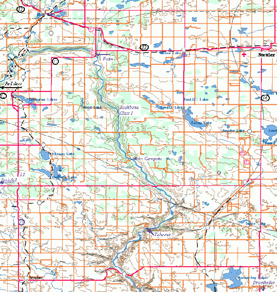
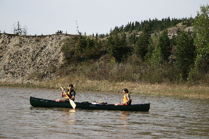
Rich and Suz
There is no question this trip is a float. The reading we have done before hand indicates one of the risks is actually running into considerable head winds, which can slow you down to a crawl, or stop you. We do not have this issue the first day, and are pushed down river by a tail wind. After leaving the Content Bridge park/campsite, we float under Content Bridge, and past the river creek Campground. Soon around the bend the noises of the road fade and then they are gone. The Hwy does not follow the river, and car traffic is rarely heard. It is a relaxing float for sure.
The first day is two or three hours, with the wind at our back, and the river running quite high we make good time. We see deer, lots of swallows in the dirt cliffs. The scenery is very much park land, which is to say, mostly covered in mixed pine, poplar trees and open areas.

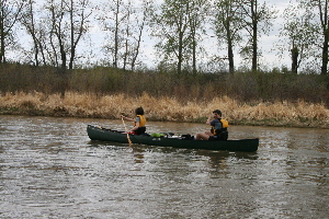
big white birds on day 1
At one point we notice that there are large white things on the shore down river. They turn out to American Pelicans, at first they are on the shore, and take off before we can get even with them. They fly downstream, eventually turn around and fly back upstream past us. They are surprisingly graceful flyers. The next day we see them again, this time they do not fly away, and have a buddy hanging out with them. The buddy is a Canadian goose, which looks small next to these big boys.
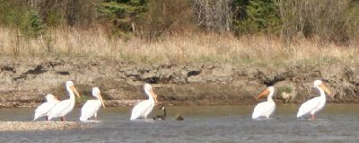
Canada goose hanging out withthe pelicans
There is one rapid on this section of the river, it is named Backbone. According to the paddler’s guide to the Middle Red Dee river, by Clayton Roth, “Most likely the crossing point for Anthony Henday in Oct of 1754”. This Rapid is not quite ˝ way between our put in and our first camp on the island out from Trentville park campsite. At the water levels today, the rapid is a small gentle sloping drop and a few bumpy waves. We run it on the left channel around the small island in the top of the rapid.
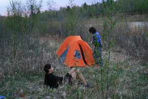
part of our camp site
Our campsite is on the island that is out from the Trentville park campsite. For some reason it seems to me that the best place to camp often seems to be at the downstream end of the island. We Stop at the top of the island and explore. We bushwhack through the tall willows. Eventually getting to the downstream side of the island, sure enough it looks like the best spot. Unfortunately it is taken. We walk back to where Suz is waiting at the top of the island (she did not want to bushwhack with shorts on). I’m not sure why, but I prefer to camp in or near the trees, and do not like the gravel bar on the front of the island. I convince the Rich and Suz we should go towards the back and camp in the grass on the edge of the trees. After getting down there, Suz comments that it is the strangest campsite she has ever used in.
Our site is amongst the grass, which right now contains a lot of last year’s growth, all bone dry. We decide not to light a fire in an old fire ring that is overgrown in the grass. But we have brought steak to cook. The river is fairly fast on the side of the bank. I end up lining Rich and Suz back up the side of the island, so we can light a fire on the gravel bar. I’m trying out something called a “Grill Master”, which is a grill basket, with a grill top, and a handle. The steak gets dropped in the fire, and pulled out (twice), but turns out not to bad. It starts a light short rain just as we are cleaning up from supper.
A turn out the time on my GPS is 2 hrs fast... so we are camping pretty early. I forgot my fishing rod in my car. Thing about camping on a small island, there is not much to do. But that did not stop some crazy Russian from swimming across the river to hang out with the other group. He was drunk, and well... crazy. Yelling and swearing, trying to pick a fight with the one guy there, pulled a knife. (We found out about that the next morning when we were chit chatting with the other group). He was drunk and celebrating in his own way the victory of Russia over the Canadians in the junior hockey champion ship.
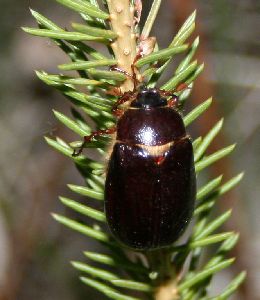
Big bug
We sat around a bit, and watched the big beetles of some kind flying around. They were making the drunken flight of bumble bees look reasonable. Maybe they are Russian and were celebrating too.
The next day we paddle across the river to check out Trentville park campsite. It actually looks like a fairly nice place. It seems to be heavy on the RV traffic, as opposed to tents, there is a tenting only section next to the playground, so no doubt noisy, the tenting section we saw seems small. Otherwise it looks like a well run, and clean. Lots of trees, on the river, no major road running past, the best of the sites we see on the trip.
Time to get back on the river, and continue our float.
Rich and Suz spot something floating in the water, just above the surface. They check it out, and pull out a 45 gallon plastic barrel. They load it on the canoe, when we stop for a snack at big valley campsite (at the Hwy 590 bridge), we leave it as a garbage bin. This campsite seems to be under renovations for the spring, it looks like it needs a fair bit more work though. It does not look like that nice a place to camp just now.
Rich showing Suz the latest trend in holding the canoe paddle
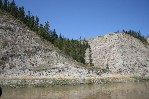
From here it is 14km to Dry Island buffalo Jump, where Rich’s car is patiently waiting for us. It is not long after this point that we start to see the beginning of the badlands type scenery, something I’ve not seen since I was very young. I find even this initial semi-badland type formations very interesting. To me it is very strange that there can be a layer of rock with sandy dirt under it. I guess something stopped a layer of minerals as they seeped down, which later formed into rocks. Some of the banks have mini hoodoos on them.
IMG_1462.JPG
Soon we see the sign ‘entering Dry island buffalo jump Provincial Park’. It has been a short day, we know the canoeing part of the trip is nearly over. This is as planned, as we hoped to have time to go on a short hike in the park.
However, as is often the case on my trips I’ve failed to mark the takeout on the GPS when we left the car there. This time we did not even walk to the river to take a look, as we were in a hurry to get back to the put in. So neither Rich nor I were sure how we would recognise the take out. So it was the discussion started about where we were on the paper map, which showed the take out, and the GPS map which should our location, but not the take out. Rich comments,” as long as we do not see a sign saying exiting the park”. Sure enough 5 minutes later we see a small sign nailed to a tree ‘provincial park boundary’. Now the map checking takes on an honest intensity. As we are checking maps, Rich staring at the paper one, me looking at the GPS, neither in the same boat... I’m about to comment, “it should be right beside you, as they are a bit downstream from me, and my GPS map does show the picnic area which is a 100m or so from the stream. Suz is already quietly paddling into the ramp, which is hidden from me by the shore line. Rich is still staring at the map until he looks up just before they land.
At shore we cook tortellini for lunch, then go for a hike around the park. I must say it is a very interesting eco system / landscape. Watch out for stepping on cacti. We do a 1-2hour hike/scramble on the ‘cliffs’. The hike makes for a very interesting couple of hours. I definitely want to check out the badlands some more.
Two notes about our takeout: first no camping is permitted here, second the road is impassable if it is wet, as it is a steep gravel road
You can get the Clayton Roth map at www.abcanoekayak.org , I bought mine at MEC. Get the “Middle Red Deer River Dickson to Drumheller”. Not the other Red Deer River map. Mark Lund’s book ‘guide for Alberta paddlers’ also covers this river but we’d forgotten it in the car and did not reference it during the trip.
|