Hike: Castle Mountain - The Fire Lookout
Quick Summary
Difficulty: Easy (short, kinda steap)
Distance: 4.7
Elevation gain: about 500m
Time Taken: 3 hours
Cool points: not much
What it's Not:
Date of Hike: Mid Aug 2002
Recommendations:
Notes: This is a short, and
moderately steep hike, you end up with a bit of
a view of the bow Valley, including the Bow river,
and Hwy 1 snaking through it. It goes up and ends at
the foundations of an old fire look out, situated
near the base of the cliffs of Castle mountain.
|

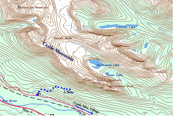
"Map is © Her Majesty the Queen in Right of Canada,
Department of Natural Resources. All rights reserved."
map from the website
http://toporama.cits.rncan.gc.ca/toporama_en.html
|
How to get to the trail head
To get to the trail head from Calgary, follow Hwy 1
to the Castle mountain junction (Hwy 93) it is past
the banff townsite, it taks better than an hour to get
there. Turn right, Follow the road accross the Bow
River, and turn left on ___ 1A, Follow this ____ and
turn right in to the trail head parking lot.
Ramble on about the hike
This is the first hike of the season for me (and the
seasons almost over now. Suggested to my wife and I
by our friend Steve. 4.7km, at the Castle Mountain.
I was interested right away, I've always wanted to
do some hiking in back around this moutain. It is
a very impressive chunk of rock that I've driven
by serveral times on the way to the ski hill, or on
my way out to BC.
This is a well maintained trail, at the trail head is
a topographical map of castle mountain showing the
trail that you will be following.
As the name implies this is a hike to an old fire
lookout. The fire lookout itself hass been taken down
as the Parks system fire lookouts were abandoned in
the 1970's.
The hike starts out in the trees, crosses a tiny stream
and begins to climb up the side of Castle mountain. The
Trail is well treveled, we passed two famillies with
fairly yong kids. The one familly had one girl that was
still in diapers, so I'd put her at 2-3 years old.
Anyways, the hike is actualy fairly steap, we took
our time. it climbs in through the trees, occasionally
giving glimpses of the ramparts of Castle mountain up
in front of us on the right, and the Bow River and
valley down below.
About 1/3 or so along the trail, there is a small,
old and abandoned cabin. I think it was used to store
supplies for the fire lookout. I'm not sure, just
a suspision, It could have been from the days when the
internment camp was set up, not to far from here during
WW1.
A little past the 1/2 point the trail opens up out of
the trees a bit, giving a view along the valley. Actually
a view of two valleys, as this hike is close to the
junction point of the _______ valley and the _____ valley.
Down below we can see the Bow river winding its way
towards Banff. One of these days I'm going to drop my
canoe in up here and paddle down to Banff, or Canmore.
The tril comes to ba bit of a dry gulch, where we
snapped the first picture. Believe it or not we are
getting pretty tired at this point. How terrible, it is
be be this out of shape. Even Steve's dog is getting
tired, and she is on a leash. After the gulch, we come
to some switch backs, the trail is not nealy as defined
as it was at the start, but is still very well traveled.
just that people are short cutting the switch backs.
Too bad people are so ignorant as to what this does in
terms of errosion. Stuff like that is more expected
on the short easy trails, as the users tend to be a bit
less out door savy.
Snapped a few more pictures along the open area the
trail was going through and along the switch backs.
The trail seemed to be longer that ne 4.7 in the
trail guide. I was actually wondering if the guide
was old and that the trail had been extended by lots
of use over the years. However soon we did indeed come
to the foundation where the fire lookout had stood.
The view was OK, not great as we did not have alot
of elevation, and the valley was a bit smokey, or
misty. I liked being in somewhat close to the cliffs
of Castle mountain. I did take several pictures of
the valley.
Lessons Learned on this trip.
Concluding thoughts
The Hike would make a good early season warm up
hike (I think) the trail is low, and faces West,
but has exposure to the southern Sun. I expect it
would be open fairly early. However, for me the
lack of a climax, or spectacular views, makes this
a hike that I would not recommend as a short day hike.
[an error occurred while processing this directive]


