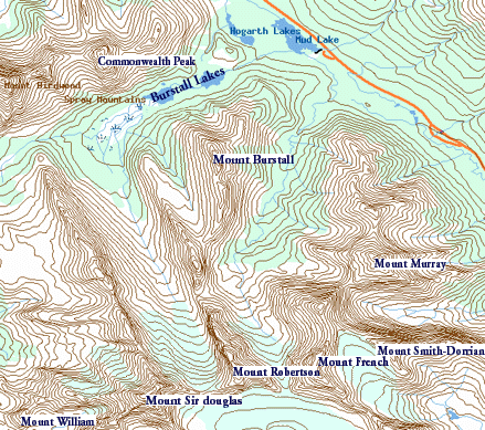
The trail head:
The trail head is shared with the trail head for the 'famous'
Burstall pass hike, it is located on the Smith-Dorrien Spray
trail (742) , xxx km
south from Canmore, or xxxx km north from the Hwy 40
junction, it is on the West side of the road.
Ramble on about the hike
This summer has been a busy one for me, I bought a house last December
and it seems to suck a lot of my spare time out
(hopefully I'll have a deck and
grass by the end of this summer). I'm getting married,(actually got
at the time of typing this), and that sucks even more time than the house.
So this is actually my first hiking trip into the mountains this year...
seems
like I am never getting out enough every year... once again I hope that
will change next year once I am more settled in. Any ways, enough of
the self pity.
As I said this day hike was part of a three day camping trip, a lot
of our time on the first day was spent meeting in Banff (Chris and
Randy are both from hundreds of mile away so it was a pretty late
meeting), and then
getting to and setting up camp. We ended up staying at the Mount Sarrail
camping site, tents only which was okay,no showers though,
I cant stand the drive in campsites with
all the RVs... not sure why, just feels like I am still in the city.
Saturday while waiting for Randy and I to show up in Banff, Chris
spent some time reading his 'Opinionated guide on hikes in the rockies'
or some similar title. And decided that the Burstall pass would
be a great day hike to try on Sunday. Since the trial was in Kananaskis,
we headed out through Canmore (where we had to stop to fix a blowout),
then south on the Spray Lakes/ Smith-Dorrien trail. follow this until
it ends at a 'T' and turn right. Follow this road for around 10km, the
Mount Sarrail camp site is around 3km before the end of the road, and
is between the the Upper and Lower Kananaskis lake (but not on the
shore of either)
So Sunday up bright and early (10:00 is bright an early
when you have a hangover). We set out back up the Spray lakes/
Smith Dorrien trail. We knew where the trail head was from
the trip down the night before, and easily found it... perhaps
a little to easily. With typical 'who needs to ask for directions'
we set out on the trial. Of course we had looked at the map earlier,
we did not want to go around the Hogarth lakes, so we made sure to keep
to the left when the trail forked. (Bad choice if you really
have your heart set on doing Burstall pass).
I'm not sure what trail we were following after we turned,
it is not Burstall Pass, or Hogarth lakes. (I think that fork in the
path is maybe 300 m further up the trail). In-fact we were not
even on the French creek trail (that fork is further up the
trail too) Anyways, the one good thing
is that this trail eventually crosses French creek on
a 'bridge' (well it crossed the creek, but I think it was for
diverting high waters ??) Anyways quickly after this our trail
went from a wide track that seems to have had vehicular traffic
to what appeared to be an old road, not used in around 10 year.
our 'trail' continued along this, it involved a lot of pushing
past and trough new trees, all dripping wet from the dew or
an early morning rain. Oh well, by now we were trying to figure
out what was going on with the trail, the book I have mentions
following an old logging road, past Mud lake. Well we seemed to
be on an old logging road, and the bridge we passed had a bit of
a slew next to it... Being in no danger of getting lost we pressed
on assuming we would cross the main trail eventually, or just have
to head back the way we came.
Continuing towards the west expecting to hit the trail and the
Burstall lakes, we eventually hit a more traveled (but lightly
traveled trail) and our spirits went up. Sure enough this trail
came up to a small creek, and our hike was on in earnest. The trail
followed the creek, and was occasionally washed out by it and often
it split picking different paths along the bank. We have now been
on the trip of abound an hour, and are expecting to come to the Burstall
lakes, soon it is an hour and a half.... mean while the trail has
left the creek and follows up along the the side of the hill well
into the trees. I'm pretty sure I can hear water falls (it is often
hard to tell water falls from wind in the trees... I often think I
hear water when it is not). We are now really trying to figure out
what is going on with the trail. Although we are on a definite trail,
it is nothing like what we expected Burstall pass to be like. With no
crossing of a real trail, it became apparent we were not on the
right path. later we could hear what sounded like a second set of
falls.... pulling out the book for about the 5th time, we see that
the French Creek trail has water falls, and the sky line matched
this valley rather than the Burstall creek valley.
Oh well, we were well along the trail long enough, we were not
about to go back now. It is around 2:00, we've been on the trail for
about 3 hours. Chris is starting to worry for time, we set the turn
around time for 4:00pm. (its mid summer after all). The Trail comes to
the stream and follows it for a while then leaves it and continues
the left side in the trees.... at least that is typical of the path
we were taking. On the way up we only came to one set of falls. This
trail has 3 sets, and we walk past the rest in the trees. The
trail is not heavily travelled, and often forks, we lost it a number
of time... and we were now comming to a lot snow on the North side of
Cgenfs and mount Murry. This make us loose the trail often... luckily
the trail is also a skiing trail, and by some magic these folks stay
on it even when it is buried under snow. (I only saw one marker on
the trees the whole time out... maybe we never spent much time on
the trail after all).
We have now passed the length
Mount Burstall (its around 3km long) to the West,
and I wonder about scrambling up
between it and Piggly Plus and then perhaps get down into Burstall
pass on the other side, It looks like we could get up, and the
map in my book shows a pretty easy decent on the other side. I mention
it but Chris and Randy are Leary and would rather press on to French
Glacier at the end of the trail.
After we come past one of the spurs down from Mount Murry, the
snow becomes patches of snow and it was easy to find the trail. this
continues along French creek. to the West is Piggly Plus, West of that
we still see Mount Burstall, to the north the valley opens out, although
it is pretty much closed in by now. To the east we have passed Cegnfs.
we are now even with a peak which I do not know the name. and to the
south are the two more spectacular mountains in the valley, Mt French,
and Mt. Robertson. The valley is full of skree, and ____ (droppings from
a glacier) but where is the Glacier??? It has obviously receded some
what since my map was drawn, we can see it coming down from between
Mt French and Mt. Robertson. However according to my map it should be
a fair bit further into the valley. Perhaps it is still there, just under
all the rock.
We take a quick jaunt up the left side of the peak between Mt. Murry and
Mt. French. There we climb up a lager bolder on the edge of one of
the 'snow patches'. The patch of snow had been wind sweep around our
lunch rock, and we could see, that no more than 20 feet in from the
edge of the snow patch it was a good 8 feet deep. I wonder how long
this snow had been here? from just last winter, or had it been a 'few'
years. Sitting on our rock we had lunch, followed by a nice 1/2 hour snooze.
There is nothing like having a snooze on a hard rock in an upper valley,
it sure is peace full, except the odd jet flying way over head which we
could actually hear way out away from the noise of the city.
Our weather had been partly cloudy all day, with occasional light rain.
Lunch was during a nice sunny break in the weather.
After the snooze we set our course, decide we will attempt to go over
the ridge between Piggly Plus and Mt. Robertson, and if possible make it
down to Burstall pass. But first we had to travel back down into the
valley to get up the other side. And here we had a fairly steep snow
patch going on for around 80 m or so.... The slide was on. (More on
this latter... don't do it, it is very dangerous as we found out later)
It sure was fun though. I forget when it became apparent that Randy's
shoe was breaking up, but the slide down the snow patch filled it with
snow. This is bad news... when you are way in the mountains. Did we
turn back... nope, out came the duct tape, three or four wraps and on we
went.
Deciding to attempt the pass was a lets, see what we can do type
decision. Chris and Randy both thought we would end up turning back.
I thought we could at least make it to the ridge and get a good view,
maybe even continue down the other side. This 'pass' came complete with
a snow patch running down from the top all the way to the creek. However
this was obviously not just a snow patch from last winter, you could
see the blue of ice coming out from it in patches. Although I am
not an expert, it looked like a small 'shallow' glacier to me. It was
obviously not something we would slide down for fear of falling into
a crevas, not to mention it was very steep. We would go up
on the south side of the 'glacier, and either go around it at the
top, or perhaps cross at a narrow section.
Up this high in the valley the French Creek was pretty small, and
a quick jump and we all made it across without getting to wet. We
began our scramble up the side. Randy's shoe was holding up, and
apparently the duct tape was not to slippery on the surfaces which
were smooth. we were probably around 1/2 to 2/3s of the way up the
valley when it started to rain. I felt pretty comfortable going up
dry, even with Randy's shoe but in the rain we decided it would be
to treacherous to continue up. So it was that we turned back.
The hike down from the pass was pretty quick, after we went
down part way, Chris went on a head with the camera and took a picture
back up at Randy and myself. (I'll update the page with pictures,
once Chris gets them scanned in and sent to me). Randy and I actually
ended up sliding down at the edge of our glacier being careful not
more than a few feet out into the snow field. The time was now
approaching 4:30 - 5:00 or so, past our turn around time, but giving us
more than enough time to get down in light.
On our way down we made it to one of the falls which we missed on the
way up. (pictures forth coming). Here Chris and I crossed the stream,
which is now Shin deep, pretty fast and cold. Continuing on, we are
not on the same trail we came in on but one of the forks. We do
end up coming out on the 'real' French creek trail according to my book.
Ironically this required us to ford the creek again as the old bridge was
washed out. However after this the trail is definitely what was once
a well traveled road, and is not possible to loose. We ended up stumbling
to the trail head around an hour later, with the first hike of the
season complete.
Lessons Learned
Now that we completed our hike, we decided to read about French
Creek trail in the car ride back to camp.
One of the very first thing the book mentions is
"Thouse inoccent looking snow fields have snared quite a few people,
including a ranger fortuitously accompanied by two search and rescue
experts. Rather than freeze to death down a cravasse, I suggest spending
more times enjoying the water falls" - Gillean Daffern, Kananaskis
country trail guide. I agree.
Expect this page to be updated with pictures... Chris took some,
and he promised to get me some digital versions
[an error occurred while processing this directive]