Trail Description:
The trail head to Stanley Glacier Trail is just a few minutes in side the BC border on HWY 93. It is set in a recent forest fire burn, by recent I estimate 10-15yrs ago. Somewhat surprisingly, this adds positively to the hike a fair bit, as the first part of the trail is not the usual walk thought the evergreens typical of trails in this part of the world.
Today is another hike with my new hiking partner Kaylyn, my 6yr old daughter. We've gone camping for the weekend, and have joined up with two Spanish families for the hike.
The trail head is just of Hwy 93, and is complete with a bathroom (out house I assume). The trail itself is a maintained, wide and well traveled route. It starts with a bridge crossing the Vermilion River, which runs along the side of the highway. We are close to the Alberta border, which coincides with the continental divide, and the river is really a small creek.
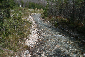
Vermilion River... A baby picture
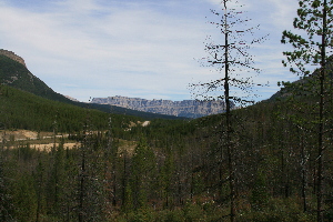
Castle Mountain in the background
The trail starts to gain elevation right away, however it is a fairly gentle climb as you occasionally switch-back up through the burned out forest. This forest has has several years to recover, making for a surprisingly scenic hike through the trees that are there, allowing for lots of smaller plants such as flower to flourish. It is also quite sparse of larger trees that are alive, affording more views than would otherwise be part of a hike through the spruce and pines. This did not seem to detract from the nature of the forest itself... which I found some what surprising.
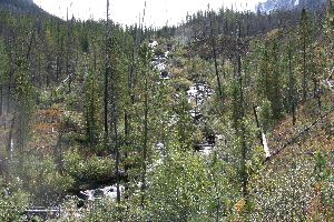
Stanley Creek
One of the nice features of this hike, is that it follows and crosses Stanley creek.
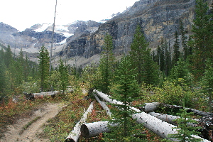
Although a fairly easy hike, as hikes go, it was still more than one hiker could handle, as she was forced to turn back. She should have continued on as she was nearly past the "hard part". After the first 2 or so kilometers the trail starts to enter the upper canyon, and levels out.
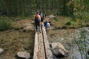
Traffic jam at the upper bridge
There is a handy three log bridge in place, to allow crossing Stanley creek. From this point on the dominating features are the high walls of a shear drop to the west. Although you remain within the trees for the first part of the walk into the canyon, it is often in view.
Looking into the canyon
In a km or so the trees in the upper canyon thin out even more, you can see Stanley Glacier off at the end of the canyon. Also the small water fall that is the source of Stanley creek, by small I mean the amount of water, the it looks to be 100m or so in height.
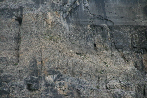
Close up of goat
Today this trail has a fair number of people on it, we see 30-40 in our hike. This proves a boon, as we see a group pointing to the side of the cliff at what turns out to be a mountain goat off in the middle of the cliff. From this distance it is a bit bigger than a small white dot, only big enough that you can make out features like legs once you realize it is a goat. This guy is up 30-40m above the scree below, and from our position he looks like he is standing on a nearly shear cliff face. We spend several minutes watching him walk along the side of the cliff, at one point he jumps down about 5-7ft and lands on a small ledge below him. Pretty amazing the ability these animals have to move on the face of a cliff.
The trail leaves the trees completely, and you end up out on the rock pile out in the middle of the canyon. Soon after the officially maintained trail ends. However since you are out of the trees, it is easy enough to carry on, on the trails that have been created by hundreds of people out walking in the bolder and scree fields in the canyon.
Keep your eyes peeled for the Marmots in the area. There are several of them, but they are hard to see. This group was a quite group, I did not hear any whistles from them. they are there, usually betraying themselves when they move. We did hear and see several pikas as well.
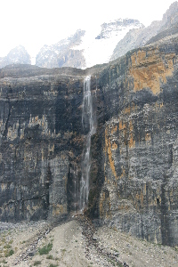
The falls
The maintained portion of the trail ends more or less even with the falls streaming down the peak. The stream flowing from the base of the falls is fairly short, and soon disappears into the bolders. We continued a little further from the end of the trail, going off trail a bit. We went past the large rock that dominates the boulder field, and up to the end of the stream. It is as we were returning that I saw the marmots, and we went down to get a closer look.
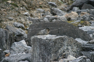
marmot, easier to see.
When we got to about 15m from the marmots, I'd thought they had scurried away. However as my daughter left the trail and went right up to the rock one of them was sitting on. She ended up sitting on the rock for a while looking down. It was only after she got back to he trail that she told me she was singing a "marmot song" to the marmot which was only 3 ft away from her, and according to her came closer to listen.
There are several choices for trails that continue up the canyon, and I assume to Stanley glacier, however we decide to head back. We've come 5-6km so far, and that is pretty good for Kaylyn who is only 6yrs old. Make no mistake we see several children on the trail, one of the boys in our group is younger than Kaylyn so it seems to be a reasonable hike for children. The youngest we saw was a 3week old baby being hiked up by her mom.
One closing note, I've taken the map above from the geogratis.ca website. The trail shown is not upto date, as the trail crosses the creek, and continues on the West side of the creek once in the upper canyon.
|