The Trip Report:
My wife planned a few day's vacation to Waterton. I was not overly keen. The 3hr drive seems a bit long given I can see the Rockies from my house, and it is an hour or so to Kananaskis or Banff.
It was a motel kind of trip, which I'm also not overly keen on. We booked very late, probably 2 days before day one, and ended up staying at the Heritage in in Pincher Creek.
Day 1 was the drive, where on the Way from Cochrane we made a detour to the Frank slide center. We were also going to go on a tour of the Bellview coal mine, but were a bit late getting there and missed the last tour. I'd say even so the detour was worth it, it added a bit to the drive, but also broke it up. The center itself was interesting and I thought well done. A bit depressing though.
We got to our Hotel, registered around 7:00, and drove in to Waterton for a quick recee, and supper. First impressions of the town site is that it is much less over run with tourists than Banff, the main strip is considerably smaller. I like the older houses. I find I like this setting much better than Banff. The beach along the lake had a few other people, maybe 6 in the close vicinity, and 30 or so over the 200m or so length around us. There is a bit of a line up at the boat tour, loading onto the boat.
We spend a bit of time skipping rocks and admiring the scenery. To the North is the ubiquitous view of the Prince of Wales hotel up on the last hill before the mountains abruptly transition into the plains. Across the lake to the East is Mt. Vimy. There is lots of colour in the rocks on the beach, yellow, white, red, dark of granite, etc. Looking across the way you can see lots of colour, especially red in the face of Mt. Vimy. the late afternoon sun from the west really sets it off. As my daughter said, it is really pretty.
On West side of the town you can see the burnt forest from last year (or was it the year before?). Not as scared as one may think, meaning it did not take away from the view all that much, nor did it make the mountain look like some sort of charred husk. I guess what I'm saying is that if you are not going because of the fire then it is not much of an excuse. although having said that several of the trails to the west are closed right now.
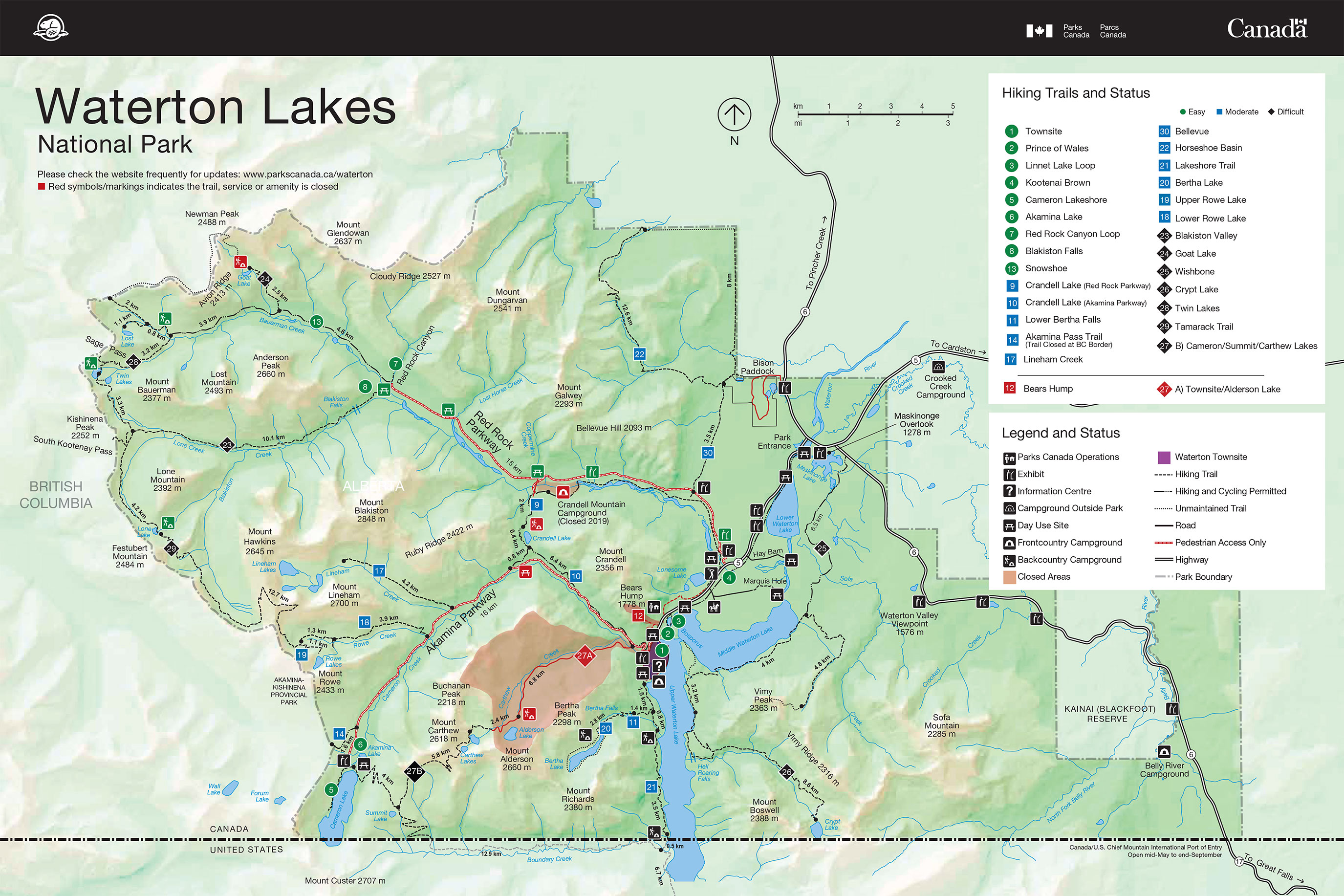
Cameron Falls - Waterton town
A short 3 or 4 block walk West from the main road just off the beach will bring you to Cameron falls. Water falls are always nice. These come down through a canyon, they are not large or large in volume. I'll guess 12 csm, but the are pretty interesting. there is a portion of the water that branches off and runs along the side of the cliff. It is definitely worth the short walk to get there. there is a short paved 'hike' up along the East side of the fall, it is fenced. Also the walk runs pas a play ground, for those of us with kids.
That was it for the fist day. I will say that I very much preferred the town site of Waterton lake to Banff. Much less crowded
The next day, after breakfast, we washed the boats at the Pincher creek car wash, and made the 45 minute trip to our paddling put in. we choose the beach/picnic area just before the Prince of Wales hotel, marked as Linnet lake loop (3) on the map.
Put in.
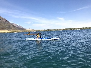
Once on the water there is a short paddle along the West shore, and then a cross the narrow channel between Middle and Upper Waterton lake. As you cross looking back the hotel up on the West side comes in to view. quite a few people taking in the view of the lake and surrounding mountains. We never did go up on the bluff the to check the hotel out. I'm not really sure how that happened. The view is quite nice even from where we are at water level.
The original plan is to run down the lake a few km to where the Crypt lake trail head is. The same place the tour boats are heading out to. However the wind is blowing a little bit and seems to be on the rise, the fetch is enough that the waves are starting to pick up, and I decide we are heading back. (of course the wind died down soon enough). We stopped when we got back to the narrows.
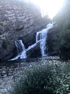
Prince of Wales Hotel from across the narrows - Waterton Natnl park
Lunch, was a quick affair, I've already forgotten what it was. l do remember the non typical view of the hotel, and the people up there. As the kids and i were skipping rocks we also watched a pod of 20 or so paddle boarders go from to middle lake to the West shore. Also a few canoeists and kayakers heading out to the East side along the South shore, the same route we will be taking, which is nice and sheltered from the wind and waves. The tour boats all go South, but a few motor boats do move onto the Middle lake through the marked channel
MIddle Waterton Lake Looking North
After lunch we continue the paddle in the shelter of the point jutting out to separate the Upper and Middle Waterton lakes. The canoeists we watched during lunch have stopped around 1/2 way down the shore and are jumping into the lake from about 10-15' above the water. At least a few of them are, that water is cold.
There are a couple power boats out on the water. the lake is large enough that they do not bother hardly at all, not that they normally do, really it is just the noise. Today I think because the are staying a reasonable distance away, and there are only two, and zero jet skis.
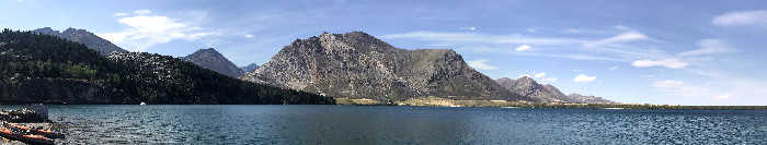
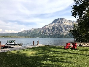
Crandell Mountain from the SE shore of Middle Waterton lake
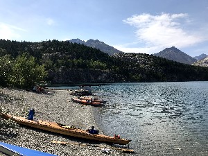
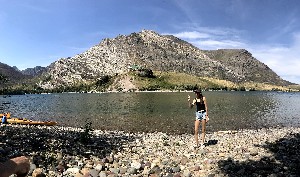
Water Skier's beach.
We stop and get out at something called the water skier's beach it has the derelict permanents of some kind of dock, and is on the South side of the East shore. The beach has a more pebbled shore on the north side of the pier and is better to pull the boats out on to.
It is a nice day for both a nap, which my wife takes in the shade of a tree after paddling like a possessed person. I did tell her to slow down a few times. It is a classic mistake (according to me anyways ) for a new bow paddler. The oldest daughter tries swimming in the lake, while the youngest and I walk the beach skipping rocks. She does try taking pictures with her phone under water while protected by a sandwich bag.
It was good to have the whole family out on the water at once. The new Yost kayak is holding up and although tender did not tip once with Dana and Kaylyn out chasing each other around. (Neither did the guillemot... as expected).
One final note we were treated to an amazing silhouette of a stag standing on a ridge right at the edge of the highway as we were driving back to hotel. We slowed down, he waited for us to pass and calmly walked across the road. Man he had a nice rack. It is a reasonably nice drive, Although I'm not sure I recommend staying in Pincher creek just to save a couple hundred bucks, given the time driving and the convenience of walking to your hotel if you stay in the park. For us by the time we booked the vacation the Waterton hotels were full, and Pincher Cr. is definitely a reasonable 2nd choice option.
|