Paddle: Upper Kananaskis Lake
Quick Summary
Date: July 24, 2004
Summary: A Paddel around the Upper Kananaskis Lake
Surounded by Mountains, clear blue sky.
Distance of trip: 14.4 km
Time Taken: 3.5 hrs (22mins stopped)
Ave Speed: 4.7 km/hr (moving ave)
How to get to the set in point: Hwy 1 west from
Calgary, South on Hwy 40, then west on Kananaskis lakes road.
(??)
River Grade: Lake, calm day
Paddleiing partners: solo trip
Weather Conditions: Sunny, calm/light breeze
+28DegC in Calgary
Trip rating: Good.
The Good:
- Scenery,
- Weather.
- Not super crowded.. parking lot 1/2 full.
The Not so Good:
- Motorized boats on the lake, not many, and mostly fishing,
- Damed lake looks some what 'dead' chopped tree stumps just
above and below the water level, little water vegitation.
Boat style used: Sea kayak
|
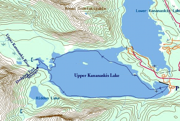
"Map is © Her Majesty the Queen in Right of Canada,
Department of Natural Resources. All rights reserved."
map from the website http://toporama.cits.rncan.gc.ca/toporama_en.html
|
The paddle report
This is a pretty simple paddle. No rapids, no giant waves, no
adrenalan. Okay enough about what it was not. What was it.
First getting there is a very nice drive down hwy 40. Complete with the
obiligitory Mtn. Goats on the side of the raod. This time with some very cute
and cuddley looking kids. The mountains them selves stand like sentinals,
guarding against what I'm not sure, but majestic just with their presence. Not
much snow left on them just the odd highlight up in the grey, above the green
of the evergreens, and the colours of the grass and flowers.
In amongst this is nessled the Upper and Lower Kananaskis lakes. Both
damed lakes. With the upper flowing down to the lower. It is here that the
film X-men was filmed. Today I chose to paddle the Upper lake, a simple paddle
around the circumfrance.
Both previous times I've been here (May 2004 and June 2000) the lake has
still been frozen. I've just driven to the boat launch and turned around.
From the boat launch the Upper lake looks like little more than some sort of
small rock bound pond. Infact when it is frozen, it looks positivley barren
and forlorn. However, later looking at the map I saw that it is much bigger
and that is just a bay.
today (July 24), it is Hot, and the lake is definately not frozen. Infact
after loading the kayak with some dry cloths, and lunch. I choose not to don
the wet suit. It is that warm, with very little breeze. The water is cool,
Between it and the elevation of the lake, the temperature is very nice. I do
not want to swim right now, maybe at the end of the trip. There is almost no
risk of a acidental tip with the current conditions. However on go the Life
jacket and skirt, just in case.
Heading out from the boat launch, there is a small peninsula, on my map it
is marked as a solid land mass. However today the water is apperently high, it
is a small rock island. I watched a canoe go around it as I was getting ready.
I head off to go between. As expected the bottom comes racign up to meet me
as I glide between the two. It is shallow. I squeese between to rocks,
missing the bottom by no more than and inch.
The main body of the lake opens up before me. To the right is Mt.
Indefetigable. A mountain I've been meaning to climb for some time. I can see
the trail up the ridge, it must have a good view of both the upper and lower
Kananaskis lakes. To the left is Mount Sarrail and "the Turret". and strait on Mt Lyautey. Behind
looking back at the launch is the valley of Elk Pass, with the solid wall
of the
Elk mtn range behind. The mountains seem a little naked as they have very
little snow on them right now.
for a bout 50 ft up from the water all the trees around this lake have
been cut as stumps. I assume prior to building the dames that make (or
perhaps enlarged) the lake. It makes for a some what grim land scape on some
of the shores. The stumps have are somewhat odd, many of them have what looks
like to be all their roots exposed, as if the dirt has been washed out from
under them, or they have all floated to shore. However with out exception they
are all staning right side up, interesting. They are not every where, and
seems to be concentrated in areas.
The stumps are also below the water level. This makes for a hazard for the
power crafts. For me they are a bit of a distraction at times as I glide over
them, or occasionally have to stear around them.
Soon after I start to move North along the east shore, I come to a
peninsula, with The trees are all dead, It looks like a fire started at the
tip, and spread in shore. It did not make it far, looks like they got this
one under control and out right away. The far side of the lake, I can
hear (in amongst the distand, and sproadic hum of motors) the sound of
rapids/falls on the far side of the lake. At first I'm not sure if it
is trully the water, or if it is wind in the trees. I can see the
'falls' and the sound sure seems to be coming from them.
As I continue along, approaching the first of the islands, I start
to think my original estimate of the paddle time is way off. From my map
the first Island is a few km out. I've already been on the water for nearly
an hour. I figured 3-4 hours for the trip, but if that's the first island
it is going to be 6 or 7 hours. Yikes, I got a late start and that will
be a long day to go all the way around.
I'm glad I brought the map. I figured the trip was around 15km. Looking
at the map, and the islands, I'm getting confused. It is not until I 'step
back' and look at the mountains that I realized the burnt out paninsula
I past 30mins ago is infact the first Island. I'm now at the second Island,
and am around 1/3 of the way through the trip. Suddenly the map makes more
sense. Looking back to the North West, is a bay, where the dam between the
two lakes is (not just a little bay prior on the map). Okay it all
makes sense, but my directinal sense is off and slightly confused. Odd, that
rarely happens if I'm on land, especially walking around the lake. I suppose
that it is because I've paddled more or less strait to the second Island, and
have missed the curvature of the lake.
After this I move in closer to shore for the rest of the trip. I make
the decision, as I find that paddleing is more interesting that way. Also
looking at the map the third Island is far enough out that it would be bad to
tip and make the swim. A small consideration given the conditions, but always
at the back of my nervious mind.
With my decision to stay in closer to shore, I'm now in the 'fishing
zone'. I'm still outside of the first boat, as I cut diagonally to the
shore. As the shore starts to bend to the south, I'm once again looking
at my map trying to figure out where I am on the lake. I'm not over estimating
the scale. I'm trying to figure out why I do not see a creek along the shore.
Still gawking back at Mount Indefatigable, and cutting for a very small island
in the lake, just off tghe shore. I'm down to, it's one of two Islands, and as
I type this I'm still not sure but think it is the spec on the map above the last
's' in the "Kananaskis River" label on the Map.
Spending my brain power on gawking and trying to figure out where I'm at,
I fail to watch where I'm going. I realize I'm about to cut accross the casting
lines of a fishing boat. I opt to head right for shore and stay out of the way
for the most part. I share some hellos with the two fishermen, they comment that
it is a great day for a paddle. I agree. They tell me the've seen the fish
jumping, and teasing them, but have not caught any yet. They speak of a
school of 'sucker' fish in the pay, and suggest I keep my eyes open.
I follow around a corner, that seems to be made of scree (or is it skree).
the It is oddly shaped. jagged 'forks' coming out into the water. I try
to run up one of the forks. but it is very shallow, and the rocks are
fresh off the mountain kind of sharp, and I decide the interest does not
out weigh the risk of damage to the kayak.
I loop into the bay a bit, Lots of jagged rocks comming up just to
the surface, some just over some just under. this would be a real
trap for a power boat at any kind of speed. No problem for me. Comeing out
the other side I see tents up along the camp site. Just in for this
penisula at the far end of the lake is the Point campsite. I come to
three ladies out sunning on a large rock off from the shore. I ask
about the site, according to them it is 1/2 full. Today should be
one of the busyest days of the year, the campsites are the road all seem
full, and the overflow sites are in operation. Looks like a good weekend
campsite, an easy paddle or hike in.
I continue around the pinisula that the campsite is on. This next
section of the lake is pretty interesting. The bottom is obviously sandy,
there are lots of the stumps in the water. Canadian geese have made their
home here or are resting for a bit. It is also not shown to the end of my
map, as I've got it folded here. towards the end I start to detect current
as I paddle against it, and slowely it becomes a stream. It is the
Upper Kananaskis River I'm paddling agast now. I can only go a short
distance as it quickly becomes a rapid which I can not go against. I
snap a few pics, and pull an eddie turn and start heading back.
On the way out of the 'upper kananaskis River delta' there is a
large concentration of stumps on the left side of the lake. I deliberatly
go wind my way through them. The water is shallow, I have to dodge the
stumps as I go. Once having to shoot over a shallow spot as I scrapped bottom.
Interesting, and a bit of a challange getting a 17ft kayak to go through
such a winding course.
Coming out I'm looking forward to seeing if I can see another good river,
perhaps falls. I'd glimpsed the fallss running into hidden lake from the
other side of the lake. Soon another bay opens up, looks to be a channel that
a river would flow out of. However, nothing. Looks like a huge bolder has
fallen in over the stream, and over the years it has lodged smaller bolders and
trees etc. Looks like a natural bridge has formed. and the stream now flows
into the lake under ground. I'm temped to get out and explore, but there is
a guy fising right at the bolder, and I'm not interested in disterbing him.
Heading back my bow is now more or less pointed back to the set in
as I continue South along the West Shore beside Mt. Sarrail. A small
stream flows in to the lake on a very small point. I hear it before
I see it. I do not see it untill I'm passing it. As I round the point,
I can hear the stream again, and low an behold the stream is now flowing
in on this side of the point. the stream can not decide which side
of the point it wishes to flow into the lake from. It has split and takes
both paths. I'm now slow enough that I stop. One of the tree stumps, is
sitting
overthe stream. The water flowing out through the roots of the tree.
Seems like it is a good picture, we'll see when I get the film developed.
I'm running out of film fast, I decide to save the last picture for
the falls I saw earlier flowing into the lake. Anoher 2km or so I come
to a fisherman in a float tube I start to go out to the outside, but
I realize that he is just outside the mouth of Sarrail Creek. I change
course and head in for the creek. It is enough like a fall, that the
cooling mist feels very nice, very refreshing. I snap what turns out
to the the last picture in the camera.
At this point there are people on the shore, at least two families
are out at the Sarrial creek. There is a nice foot bridge over the creek.
Looks to be a nice walk out from the parking lot. I paddle past the folks
on the shore for a bit. Some kids are out on the point I first paddled
'through' when I set out. They are jumping inot the lake from the rocks.
I decide to cut across the lake and check it out, as I beeline back to the
car.
Just like that the paddle is suddenly over. A nice day all in all.
[an error occurred while processing this directive]
Copyright Myrl Tanton 2005

